Backpack: Big Sandy to Elkhart Park via Fremont and Highline Trails
Segment 9: Little Seneca Lake to Island Lake
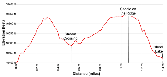
Distance: 1.4 miles (one way)
Bridger Wilderness, Bridger-Teton National Forest, near Big Sandy in Wyoming's Wind River Range
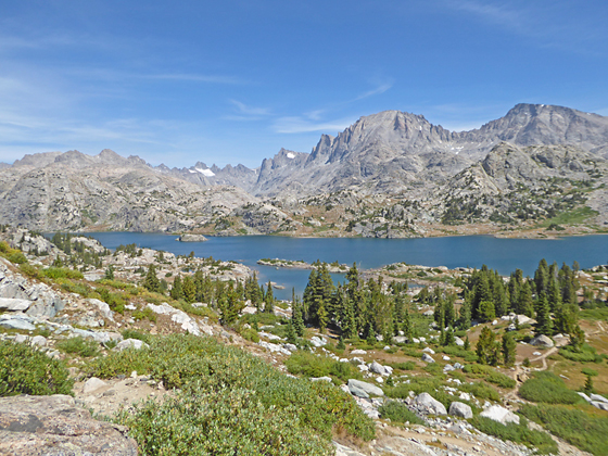
The peaks towering above Titcomb Basin form the backdrop for beautiful Island Lake
- Distance: 1.4 miles
- Elevation: 10,400-ft. at Junction Seneca Lake and Highline Trails
10,625-ft. at Top of the first hill
10,490-ft. at Stream crossing
10,640-ft. at High point of the trail
10,410-ft. at Island Lake - Difficulty: moderate-strenuous
- Basecamp: Big Sandy / Elkhart Park
- Region: Wyoming's Wind River Range
Little Seneca Lake to Island Lake Description
This description starts at the junction of the Highline/Continental Divide and Seneca Lake trails. (Note the sign at the junction lists the Continental Divide and not the Highline Trail.) Turn northeast at the junction on the combined Highline/Continental Divide Trails to reach Island Lake or Fremont Crossing. The Seneca Trail, branching west, travels around the head of Little Seneca Lake and then turns southwest toward Seneca Lake. This trail ultimately connects with the Pole Creek trail to the Elkhart Park trailhead.
Follow the Highline Trail as it ascends steep switchbacks up a rocky draw. The grade ease as the trail reaches the top of the ridge. Here you get a preview of the coming attractions with Fremont Peak (13,745-ft.) and Jackson Peak (13,517-ft.) dominating the view to the northeast.
Descend from the ridge on moderately steep grades, passing the junction of the Continental Divide/Highline trails with the Indian Pass Trail at 0.4 miles. At the junction the Continental Divide/Highline trails branch left (northwest) toward Fremont Crossing and the Jean Lakes. We continue straight ahead (downhill) toward Island Lake on the Indian Pass trail.
At the bottom of the ridge the trail traverses a small basin and crosses a creek at 0.5 miles. Here views expand to encompass Mount Helen (13,620-ft.), Mount Sacagawea (13,569-ft.) and Fremont Peak towering above Titcomb Basin. A wall of granite summits, including Bow Mountain (13,020-ft.), Arrowhead Peak (12,792-ft.) and the Titcomb Needles (12,714-ft.), fill the skyline to the northwest.
Beyond the crossing the trail climbs over a low rise and then ascends a draw on easy to moderate grades toward the top of a second ridge ridge. The grade eases at 0.9 miles as the trail passes a pretty pond with a backdrop of the peaks to the northwest. Reach the saddle (10,640-ft.) on the ridge at 1.1 miles. Beyond the saddle the trail drops on gentle grades toward Island Lake. Along the way views open to the Fremont Peak, Jackson Peak and Elephant Head towering beyond the eastern end of lake.
The grade steepens as the trail descends toward the lake. At 1.2 miles reach a viewpoint offering a stunning panorama. Here the high peaks towering above Titcomb and Indian Basins form the backdrop for Island Lake. The jagged summits of Twin Peaks (13,185-ft.), Mt. Woodrow Wilson (13,502-ft.), the Sphinx (13,258-ft.), Bob’s Tower (13,040-ft.) and Miriam Peak (13,080-ft.) rise above the head of Titcomb Basin. Mount Helen, Mount Sacagawea and Fremont Peak rim the basin’s eastern wall while American Legion Peak (13,205-ft.), the Titcomb Needles and Peak 12450, to name a few, form the western wall. Jackson Peak (13,517-ft.) and Ellingwood Peak (13,052-ft.), along with a number of unnamed summits, tower above Indian Basin to the northeast. Closer at hand, Island Lake lies nestled amid granite knolls with Elephant Head Peak rising to the east.
From the viewpoint descend steeply down a rocky slope and then through meadows with scattered trees to an unmarked junction above Island Lake’s (10,346-ft.) eastern shore at 1.4 miles. Along the way pass a few spur trails leading to campsites.
At the unmarked junction the trail branching to the left (northwest) leads to scenic campsites along the lake’s southwestern shore. The Indian Pass trail continues straight ahead (northeast) toward Indian and Titcomb Basins.
Island Lake is an extremely popular destination, so don’t expect solitude. On the knoll at the south end of the lake are tightly packed, overused campsites. Please try to avoid camping here. The further you get from the junction at the south end of the lake, the more likely you will find a campsite with some privacy. Additional campsites are located along Island Lake’s northeastern shore and in the basin above the waterfall on the northeast side of the lake. Please respect the areas closed for regeneration along Island Lake’s heavily used eastern shore.
Campsites are also located in Titcomb and Indian Basins. Both basins are above timberline so the sites are exposed with large rocks offering the only protection. Finding legal campsites that are at least 200-ft. from trails and water is somewhat challenging in both basins. Hanging food is also problematic due to the lack of trees. You will need to find a large boulder to hang your food or carry a bear container.
Return to Segment 8: Pole Creek to Little Seneca Lake
Go To Segment 10: Island Lake to Elkhart Park
Elevation Profile
Backpack Segments
- Introduction: Big Sandy to Elkhart Park via Fremont and Highline Trails
- Segment 1: Big Sandy to Marms Lake
- Segment 2: Marms Lake to Raid Lake
- --- Side Trip: Bonneville Lakes
- Segment 3: Raid Lake to Middle Fork Junction above Sandpoint Lake
- --- Side Trip: Middle Fork Lake Trail
- --- Side Trip: Middle Fork Lake via the Rainbow Lake Trail
- --- Side Trip: Photo Pass Trail
- Segment 4: Sandpoint Lake to Valley Lake Junction
- --- Side Trip: Europe Canyon and Pass
- Segment 5: Valley Lake Junction to North Fork Lake
- --- Side Trip: Hay Pass, the Golden Lakes and Fall Creek Pass
- Segment 6: North Fork Lake to Bell Lakes Junction
- Segment 7: Bell Lakes Junction to Pole Creek
- --- Side Trip: Cook and Wall Lakes
- Segment 8: Pole Creek to Little Seneca Lake
- Segment 9: Little Seneca Lake to Island Lake
- --- Side Trip: Titcomb Basin
- --- Side Trip: Indian Basin and Pass
- --- Side Trip: Island Lake Waterfall Hike
- Segment 10: Island Lake to Elkhart Park
Driving Directions to Big Sandy Trailhead
Big Sandy Trailhead: This popular trailhead is located in the southern Wind River Range next to the Big Sandy River.
Directions from Pinedale: From the intersection of Pine Street (US 191) and North Tyler Ave (the Pinedale Tourism office is located on the northeast corner) in Pinedale, WY, drive south on Highway 191 for 11.7 miles and then turn left (east) on WY-353. After 15.5 miles you will notice signs referring to the road as the Big Sandy-Elkhorn Road and after 18 miles the paved road will change to a good packed dirt/gravel surface.
Shortly after the pavement ends go straight through a junction, and drive south crossing the Big Sandy River (Buckskin Crossing). Follow the road for a total of 27.3 miles. Shortly after crossing the Big Sandy River you will reach a junction with the Lander Cutoff Road (the next junction). Turn left on the Lander Cutoff Road. There is a wood sign at the intersection pointing toward the Big Sandy trailhead.
Drive 7.0 miles on the Lander Cutoff Road and then turn left on the Big Sandy Opening Road. Here you will see a sign for the Big Sandy Campground and trailhead. The road now deteriorates and narrows. Blind corners and lush foliage along the road make it hard to see ahead. Drive carefully, following the rocky, rutted road for 9.8 miles to a "Y" intersection. Bear right at the intersection to continue along the Big Sandy Opening Road (Forest Service Road 850). (The road branching to the left leads to the Big Sandy Lodge and Mud Lake.) Follow the road for 0.8 miles to the trailhead parking area, equipped with an outhouse.
Allow an hour and a half to reach the trailhead from Pinedale. The parking area is too small for the number of backpackers visiting the area during the height of the summer. If the parking area is full, find a safe place to park off the access road.
I recommend a high clearance vehicle to reach the trailhead. Passenger cars can make it OK if driven carefully. Check at the Pinedale ranger station before starting your trip to learn about current road and trail conditions. The Ranger Station is located to the east of the Ridleys Grocery Store on US 191 (Pine Street in Pinedale). The entrance to the ranger station is on the Fremont Lake Road. (You can also reach the parking area for the ranger station by driving east through the Ridley’s parking lot.)
This trailhead is remote, so be sure to have a full tank of gas. The dirt road become slippery when wet. The campground at the parking area is tiny, with only 4 sites. I would not plan on camping at the trailhead before starting your backpack.
Elkhart Park Trailhead: From the intersection of Pine Street (US 191) and North Tyler Ave (the Pinedale Tourism office is located on the northeast corner) in Pinedale, WY, drive east on Highway 191 (East Pine Street) for 0.3 miles and bear left onto Fremont Lake Road. Follow this road for 14.3 miles and turn right into the large parking area for the Elkhart Park/Pole Creek Trailhead. After the first 3.0 miles the road will turn into Skyline Drive/Forest Service Road 370740. The trailhead is located at the northeast end of the parking lot between the outhouse and the trailhead kiosk. It should take about 25 minutes to drive the trailhead. The last section of the road has some holes and uneven spots.
Trail Resources
- Backpack Intro
- Segment Photo Gallery
- Segment Map
- Trailhead(s) Information: Big Sandy / Elkhart Park
- Region Information: Wyoming's Wind River Range
- Other Hiking Regions in: Wyoming