Backpack: Big Sandy to Elkhart Park via Fremont and Highline Trails
Segment 4: Sandpoint Lake to Valley Lake Junction
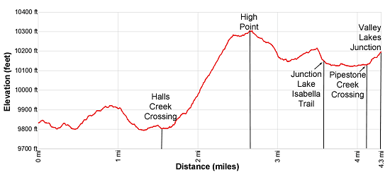
Distance: 4.3 miles (one way)
Bridger Wilderness, Bridger-Teton National Forest, near Big Sandy in Wyoming's Wind River Range
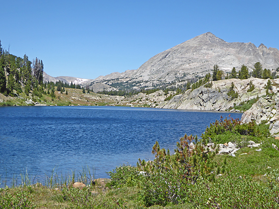
Mount Victor forms a beautiful backdrop to Pipestone Lake
- Distance: 4.3 miles
- Elevation: 9,850-ft. at Junction Middle Fork Trail
9,300-ft. at Halls Creek Crossing
10,320-ft. at High point near Hall’s Butte
10,115-ft. at Pipestone Lake
10,210-ft. at Junction Valley Lakes - Difficulty: moderate-strenuous
- Basecamp: Big Sandy / Elkhart Park
- Region: Wyoming's Wind River Range
Sandpoint Lake to Valley Lake Junction Description
At the junction of the Middle Fork and Fremont trails, the Fremont trail branches left (north) and the climbs over a low saddle between two rocky knobs, emerging above marshy meadows to the north of the Middle Fork of Boulder Creek. Here the creek turns south. We continue heading northwest on the Fremont through meadows along the east side of a narrow valley flanked by forested granite knobs. Along the way the trail travels above an unnamed lake, skirts the edge of marshy meadows and passes a small pond.
At 1.25 miles reach a small basin where Halls Creek curves to the south. The trail briefly travels along the east shore of the creek before crossing a low rise to an unmarked junction above Halls Creek. Here a use trail branches right (northeast). This is one of the unmaintained trail to Halls Lake (10,602-ft.) that soon fades. A map and off-trail navigation skills are required to reach the lake.
At the junction the Fremont trail curves to the left and drops down to and crosses Halls Creek at 1.5 miles. The broad crossing is located at a braided section of the creek. During low water it is possible to keep your feet reasonable dry by using rocks and small grassy islands to cross the creek. At other times you will need to wade across the creek.
On the west side of the creek look northwest to see a granite knob towering above the forested hillside. This is Halls Butte (10,467-ft.). The Fremont trail now climbs northwest on moderate grades through meadows and then spruce-pine forest up the rugged hillside to the east of the Butte.
Reach the top the hill near a small pond at 2.5 miles after gaining over 400-ft. in 0.9 miles. The trail now travels along an undulating route through the trees and intermittent meadows, weaving its way around boulders and granite outcroppings. Openings in the trees offer glimpses of a lake with a small island to the east of the trail. Howard Lake (10,017-ft.) lies unseen in a rocky bowl below the trail to the west.
Arrive at the high point (10,320-ft.) along this section of the trail at 2.7 miles. Here the trail starts a descent through trees that soon thin and give way to the slopes burnt during the 1988 Fayette Fire. The silvered trunks of dead trees still stand on the granite knobs above the trail.
At 3.0 miles the trail skirts the east and then north sides of marshy meadows before climbing through wildflower-filled meadows, rock outcroppings and scattered trees. As you ascend views open to Howard Lake to the southwest.
Crest the hill (10,220-ft.) above Howard Lake at 3.5 miles. To the northwest are good views of Mount Victor (12,254-ft.) and the peaks lining the canyon along the North Fork of Boulder Creek.
The trail now drops down to a junction at southeast end of the first Pipestone Lake at 3.6 miles. Here the trail to Lake Isabella turns left (south). We continue straight ahead on the Fremont trail, which soon crosses the lake’s inlet stream and then travels through meadows along the eastern lakeshore.
At 4.1 miles the trail crosses Pipestone creek, the stream linking the two Pipestone Lakes and then climbs a rocky trail up the hillside along the west side of the second lake. As you climb, enjoy nice views of Mount Medina (11,541-ft.) to the northeast.
At 4.3 miles reach an unmarked junction with the trail to Valley Lake and Europe Canyon branching right (north). Here the Fremont Trail curves to the left (northwest).
Return to Segment 3: Raid Lake to Middle Fork Junction above Sandpoint Lake
Go To Segment 5: Valley Lake Junction to North Fork Lake
Elevation Profile
Backpack Segments
- Introduction: Big Sandy to Elkhart Park via Fremont and Highline Trails
- Segment 1: Big Sandy to Marms Lake
- Segment 2: Marms Lake to Raid Lake
- --- Side Trip: Bonneville Lakes
- Segment 3: Raid Lake to Middle Fork Junction above Sandpoint Lake
- --- Side Trip: Middle Fork Lake Trail
- --- Side Trip: Middle Fork Lake via the Rainbow Lake Trail
- --- Side Trip: Photo Pass Trail
- Segment 4: Sandpoint Lake to Valley Lake Junction
- --- Side Trip: Europe Canyon and Pass
- Segment 5: Valley Lake Junction to North Fork Lake
- --- Side Trip: Hay Pass, the Golden Lakes and Fall Creek Pass
- Segment 6: North Fork Lake to Bell Lakes Junction
- Segment 7: Bell Lakes Junction to Pole Creek
- --- Side Trip: Cook and Wall Lakes
- Segment 8: Pole Creek to Little Seneca Lake
- Segment 9: Little Seneca Lake to Island Lake
- --- Side Trip: Titcomb Basin
- --- Side Trip: Indian Basin and Pass
- --- Side Trip: Island Lake Waterfall Hike
- Segment 10: Island Lake to Elkhart Park
Driving Directions to Big Sandy Trailhead
Big Sandy Trailhead: This popular trailhead is located in the southern Wind River Range next to the Big Sandy River.
Directions from Pinedale: From the intersection of Pine Street (US 191) and North Tyler Ave (the Pinedale Tourism office is located on the northeast corner) in Pinedale, WY, drive south on Highway 191 for 11.7 miles and then turn left (east) on WY-353. After 15.5 miles you will notice signs referring to the road as the Big Sandy-Elkhorn Road and after 18 miles the paved road will change to a good packed dirt/gravel surface.
Shortly after the pavement ends go straight through a junction, and drive south crossing the Big Sandy River (Buckskin Crossing). Follow the road for a total of 27.3 miles. Shortly after crossing the Big Sandy River you will reach a junction with the Lander Cutoff Road (the next junction). Turn left on the Lander Cutoff Road. There is a wood sign at the intersection pointing toward the Big Sandy trailhead.
Drive 7.0 miles on the Lander Cutoff Road and then turn left on the Big Sandy Opening Road. Here you will see a sign for the Big Sandy Campground and trailhead. The road now deteriorates and narrows. Blind corners and lush foliage along the road make it hard to see ahead. Drive carefully, following the rocky, rutted road for 9.8 miles to a "Y" intersection. Bear right at the intersection to continue along the Big Sandy Opening Road (Forest Service Road 850). (The road branching to the left leads to the Big Sandy Lodge and Mud Lake.) Follow the road for 0.8 miles to the trailhead parking area, equipped with an outhouse.
Allow an hour and a half to reach the trailhead from Pinedale. The parking area is too small for the number of backpackers visiting the area during the height of the summer. If the parking area is full, find a safe place to park off the access road.
I recommend a high clearance vehicle to reach the trailhead. Passenger cars can make it OK if driven carefully. Check at the Pinedale ranger station before starting your trip to learn about current road and trail conditions. The Ranger Station is located to the east of the Ridleys Grocery Store on US 191 (Pine Street in Pinedale). The entrance to the ranger station is on the Fremont Lake Road. (You can also reach the parking area for the ranger station by driving east through the Ridley’s parking lot.)
This trailhead is remote, so be sure to have a full tank of gas. The dirt road become slippery when wet. The campground at the parking area is tiny, with only 4 sites. I would not plan on camping at the trailhead before starting your backpack.
Elkhart Park Trailhead: From the intersection of Pine Street (US 191) and North Tyler Ave (the Pinedale Tourism office is located on the northeast corner) in Pinedale, WY, drive east on Highway 191 (East Pine Street) for 0.3 miles and bear left onto Fremont Lake Road. Follow this road for 14.3 miles and turn right into the large parking area for the Elkhart Park/Pole Creek Trailhead. After the first 3.0 miles the road will turn into Skyline Drive/Forest Service Road 370740. The trailhead is located at the northeast end of the parking lot between the outhouse and the trailhead kiosk. It should take about 25 minutes to drive the trailhead. The last section of the road has some holes and uneven spots.
Trail Resources
- Backpack Intro
- Segment Photo Gallery
- Segment Map
- Trailhead(s) Information: Big Sandy / Elkhart Park
- Region Information: Wyoming's Wind River Range
- Other Hiking Regions in: Wyoming